-
-
Colorado Snowmobile Tours
Experience Colorado’s Finest Snowmobile Adventure!
Colorado snowmobile tours are an adventure through the Colorado High Country. Our experienced guides will take you through lush forests to some of the most awesome views of the majestic Colorado Rockies. Let our professional staff help you experience Colorado. It’s the place we live, love and are proud to call home.
Snowmobiling in Colorado
Come experience Colorado’s beauty with a snowmobile vacation in Summit County Colorado area, including Breckenridge, Dillon, Frisco, Copper Mountain, Keystone, Silverthorne, and even the Vail area. High Country Tours is approximately 1 1/2 hours away from Denver. It’s the memory of a lifetime.
Colorado snowmobile tours & snowmobile rentals
We create the perfect experience of snowmobiling in Colorado by offeringguided snowmobile tours as well as unguided snowmobile rentals in the Summit County area. We are conveniently located to four of Colorado’s best ski areas – Breckenridge, Copper Mountain, Keystone and Arapahoe Basin.
Our guided snowmobile tours offer a wide range of adventures, from beginner and family tours to advanced, as well as specialized group tours and everything in between. High Country Tours has something for everyone.
High Country snowmobile tour company is dedicated to customer service and will create a customized Colorado snowmobile trip for you and your family, company, or group of friends.
Snowmobile trips that are fun & safe
Dedicated to providing our guests with the best possible snowmobile tour in Colorado, we deliver snowmobile adventures that are fun, safe, memorable, and exciting. High Country Tours snowmobile company will handle all the details including terrific meals, personalized service and the most technically advanced equipment and guides. So come and join us for the snowmobile vacation of a lifetime!
-
-
High Country Snowmobile Tours, Inc.
-
Address: 130 Main St #6, Dillon, CO 80435Phone:(970) 668-9945Hours:Open today · 8:00 am – 8:00 pm
-
Reviews
 “I really cannot say enough about my experience with High Country Tours!”“Just went on the snowmobile adventure with our family.”
Category Archives: Breckenridge Area
 Cultivatin

![]()
01/29/2013
 More Local News More Local News |
|
Vail Resorts has strong holiday performance But bad early season weather accounts for losses that are hard to make up After slow start, Summit County snowsports sales are picking up speed Local retailers say they’re coming out of a downward trend Breckenridge exhibit showcases 100 years of Summit County skiing For whatever the reason, skiers, snowboarders and other downhillers seem to love dressing up and hitting the hill in retro gear on April Fool’s Day and other holidays Dillon Marina receives top honor from national magazine Being hundreds of miles away from the ocean didn’t stop Dillon Marina from gaining recognition as being one of the best in the country
Silverthorne moving forward on downtown development plans Open house slated for Feb. 6
Snow sculptors converge on Breckenridge Event sees wide international field for 2013 competition Raising roofs in Summit County’s rocky terrain Habitat for Humanity planning new home in spring Breckenridge restaurants, retailers seeing increases Lowest vacancy rate in four years
Copper Mountain launches uphill access pass Skinners looking for early morning powder turns will be able to find them at Copper Mountain Occupancy trends looking up for Summit County lodging Positive projections for end of January, February
|
This a real great alternative activity, dog sledding with Snow Cap. Get all the details here: http://www.snowcapssleddogs.com/
or just call 970-453-PULL
We took the kids and had a blast!
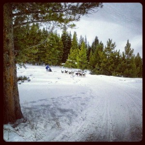
That’s me hanging on for dear life!

The Basics:
Distance: 6 Miles roundtrip to Lower Mohawk Lake, 6.8 miles roundtrip to Upper Mohawk Lake
Elevation: 1,700-foot gain
Directions: From Breckenridge, drive south on U.S. Highway 9. From the last stoplight in Breckenridge to Spruce Creek Road is about 2.4 miles, turn right on Spruce Creek Road. Drive about 1 mile to a well marked parking area and trailhead.
This is one of his favorite hikes in Colorado. I figured it was a good choice as one of my final hikes of the summer.
This is also a good place for a scavenger hunt of sorts. As you do this hike look for cabins, cabin ruins and even the ruins of a mining operation. Later I’ll tell you how many of these things I counted. You can see if your number is higher or lower.
The trail starts just outside Breckenridge, but it turns out there are two parking areas. We parked at the first parking area, 1 mile or so up the road at a sign saying “Spruce Creek Trail, Wheeler Trail Junction 1.8, Continental Falls 3.0, Mohawk Lakes 3.4.” We figured 7 miles was a good distance today so we thought we were in the right place. It turns out, you can drive another two miles up the road and cut the hike drastically. You may need a 4-wheel drive on that section of the road. Since we didn’t drive it, I can’t tell you.
Starting the hike here was a good choice for us. The trail is beautiful. It winds through thick forest with moderate elevation gains, it was actually a good warmup for what was to come. The best part about hiking through this area was listening to the trees creaking. It’s not often you hear that sound. We also watched a shower of pine needles come down when the wind would blow through. We found it a bit dark, but very quiet and peaceful. We even had two birds stop by and bounce around on the tree branches as we took a break for water and snacks.
|

At 1.8 miles in, you come to a trail junction with the Wheeler trail. Continue on just a few feet and you come to an open meadow. This gives you a beautiful view of what’s to come. You can see the nearby peaks and even the stringy Continental Falls, the waterfall where we had lunch. We took several pictures here and enjoyed our first view of the leaves changing.
We walked on about 0.3 miles and the trail ended at a parking lot. We figured this was the second parking lot. Don’t look for the trail right here, walk through the parking lot and you’ll find a trail sign; it says it’s .5 to Mayflower Lake, 1 to Lower Mohawk Lake and 1.5 to Upper Mohawk Lake.
This is where the trail starts to climb. Fortunately you know it’s not far now. Just before Mayflower Lake there’s another sign saying go right for Mayflower Lake, go left for Mohawk lakes and Continental Falls.
We decided to keep climbing and take some side trips on the way down. And climb we did. The elevation gain gets tough here at times. At least there’s lots to see. This is also where you need to start looking for items from the scavenger hunt. At this split you’ll see a few ruins of cabins.
|

Continue on to the next split. A sign tells you to turn right for a view of the lower falls or continue on to the Falls and Mohawk lakes. At this split you’ll find one cabin ruin and a cabin that has been restored. It had a sign inside calling it Continental Cabin. It said it was restored for the enjoyment of guests. I’m not sure if you can stay inside, but it had the remains of a large fire ring and even a ladder to a loft. It was a nice surprise. And a good spot to get out of the wind and rain.
We decided to add the lower falls view for the hike down and continued up. The next sign we saw was a bit off trail. It marked a mine, and we added that for the list down. Then we came across a huge contraption of some sort. Some kind a lift and pulley system, likely for the mining operation. You can still see the huge cables here for lifting and lowering ore carts.
|

It wasn’t much further from here to Lower Mohawk Lake. But when we arrived, so did the wind. Windy enough that we took a couple pictures and decided to turn around. It’s not far from here to Upper Mohawk Lake. A ranger we passed said you can actually hike to Lake 3 and Lake 4 above Mohawk Lakes. We decided this was good enough. We typically eat lunch at our lake destination, but in this case we decided the waterfall would be a better spot.
We turned around and since the hike down was much easier, we decided it was time to take a few side trips. We stopped at that mine sign. Turns out if you take the little trail over to the sign, there’s not one mine entrance, there are two. One mine had water, the other didn’t. The warning signs explain it all the dangers; mines can collapse, they can have dangerous gases, etc. We took a picture and continued on.
|

The waterfall was definitely the place to have lunch. Typically waterfalls are not much to see in September, they’re much better in spring and early summer. Not Continental Falls. It was putting on a good show in September, which means it’s probably just amazing earlier in the year. We found a rock and had lunch. We also spotted our first ore cart down in the water.
On the way down, we also sidetracked to that lower Continental Falls view. It was also a good spot to stop. And we took the side trail to Mayflower Lake. While the lake didn’t impress me much, the trail to it goes right through an old cabin. It was weird to think we were walking through what use to be someone’s living quarters.
So, our totals? We saw two lakes, one waterfall, three mines, three ore carts, one restored cabin with a roof and sides and six cabins. I’m sure there’s a lot more cabins and ore carts if you keep an eye out. At the bottom of this note, I’ll have a list of where I saw mine so you can see if you spot the same ones.
I welcome your questions, comments and hiking suggestions. Just E-mail me at, bradfordg61@gamil.com
Previous hiking reports:(lower elevation hikes have a star)
Boulder:
Caribou Ranch*, Mallory Cave*, Marshall Mesa,Heil Valley Ranch* Forsythe Canyon*, South Boulder Peak*, The Boulder Flatirons*, Walker Ranch*, Bear Peak*, Rabbit Mountain*, Bald Mountain*, Betasso Preserve*, Wonderland Lake*
Golden area:
Forgotten Valley, Chimney Gulch*, Apex Park*
Jefferson County:
Mt. Falcon*, Elk Meadow*
I-70 area:
Herman Gulch, Chicago Lakes, Chief Mountain
Rocky Mountain National Park:
Granite Falls, Twin Sisters, Bierstadt Lake, Chasm Lake, Lulu City & Little Yellowstone, The Loch, Andrew’s Glacier, Sandbeach Lake
Indian Peaks/James Peak Wilderness:
King, Bob & Betty Lakes, Forest Lakes, Arapaho Lakes, Mitchell & Blue Lakes, James Peak Area, Heart Lake
Northern Colorado:
Homestead Meadows, Devil’s Backbone*, Lake Agnes
Summit & Eagle Counties:
Booth Falls, Missouri Lakes
Grand County:
St Louis Lake, Waterfall At Snow Mountain Ranch, Granby Ranch
Other:
Exploring Fulford Cave, Our Favorite Hikes, Our Favorite Bike Rides
|

Ore carts: waterfall, below Continental Cabin, on the shoreline at Lower Mohawk Lake.
Cabins: Continental Cabin, ruins of another cabin in same meadow, cabin you walk through on way to Mayflower lake, ruins of two others nearby, ruins of a cabin at trail split to Mayflower and Mohawk lakes.
Mines: two just off trail, tailings at Lower Mohawk Lake.
This is cool!
Before people came from all over the country for Breckenridge’s views and ski slopes, they came for the gold and silver embedded in its hills.
The area is spotted with abandoned and resurrected mines that tell the story of the hard lives of some of Summit County’s earliest
residents.
Among these is the Washington Mine, located on Boreas Pass in the southwestern outskirts of Breckenridge. Meticulously preserved and carefully reconstructed by the Breckenridge Heritage Alliance, the mine is nearly a three-dimensional diorama of the town’s mining history.
What remains of the mine today was once just the small antechamber of a much bigger operation that extended up from the current site.
But local historians have salvaged and, in some cases, rebuilt a small, cute campus that nevertheless paints a pretty realistic picture.
The 90-minute to two-hour tours of the Washington Mine run twice daily most days of the week.
A great option for families with children — the tour is entertaining, dimensional and, at times, hands on — local historians lead their guests back through the pages of Breckenridge’s history, showing and telling the way people lived in and out of the mines more than 100 years ago.
Kids will have an opportunity to explore an underground mine, peer down a mine shaft, meet a tommyknocker, detonate simulation dynamite and pan for gold, exploring the local history with at least four of the five senses.
For grown-ups, there’s the tour itself, offering an insightful look into the happenstance and economics that built Breckenridge. Tour guides also cover some of the more popular local legends, with exacting historical accuracy, of course, including that of the discovery of “Tom’s Baby,” a 13-pound gold nugget.
Complete with an (interpretive) underground mine tunnel, rails for transporting gold, a prospectors cabin and all the mechanics once used to empty the earth of riches, the Washington Mine has been beautifully preserved and reconstructed by the heritage alliance and is well stocked with relics of the mining age.
Located just a few minutes outside of Breckenridge, it makes for a fun and convenient family activity that is a little more unique and interactive than the average in-town museum.
We are proud to sponcer Bike Camps through out the Summer at our Lodges!

http://www.summitmtbcamps.com/index.html
To Summit Mountain Bike Camps. Our mission is to make you a more competitive Mountain Bike Athlete.
Located in Beautiful Summit County Colorado. Location of Breckenridge, Keystone, A-Basin and Copper Mountain ski areas. Home of some of the best single track mountain biking in the world. We offer all inclusive Mountain Bike camps. All of our camps provide expert coaching, transportation, lodging, meals, cross training and training facilities packaged together in a 7 day high impact Mountain Bike Training Camp.
It is hard to believe but Breck is getting bigger!
BRECKENRIDGE — Breckenridge Resort’s plans to expand onto Peak 6 in the Tenmile Range are inching along, according to a recent update from the U.S. Forest Service. The agency plans to have a draft environmental analysis of the proposal available for public comment in the fall.
The ski area hopes to add a lift and new runs at its northern boundary. The terrain would cater to a variety of ability levels, but it would primarily feature intermediate slopes.
“That’s a significant part of the Breckenridge market,” said Roger Poirier, project team leader for the Forest Service. “What’s really driving Peak 6 is the lack of (existing) intermediate terrain.”
The proposed expansion, which would also include a restaurant and warming hut, is located inside the resort’s permit boundary.
The White River National Forest began seeking public input on the proposal in January 2008. During the scoping process, many respondents expressed concern over potential social impacts, such as parking, workforce housing and transportation. As a result, a community task force was convened and met for seven months to examine more closely the Peak 6 project’s ramifications for the local community. The Town of Breckenridge, Breckenridge Ski Resort and Summit County government are all in the process of formally adopting the task force’s findings.
“Even if there aren’t agreements on what’s going to be done, everyone acknowledges what the issues really are, and they’re formalizing their understanding of the action items to move forward with,” Poirier said.
In response to the comments from the scoping process, White River National Forest officials have modified the proposed plan and developed an additional alternative plan, which addresses concerns over natural resource issues — most notably the project’s potential impacts to the endangered Canada lynx.
The modified plan brings the lift’s bottom terminal further south, closer to existing runs than was originally proposed.
“It’s a much easier and more accessible spot for all types of skiers,” Poirier said.
A second scenario, which takes into account impacts to habitat for lynx and other species, limits the extent of development to a smaller area, closer to the existing trail network.
Forest Service officials are now analyzing each scenario, including a no-development option. They expect to release a draft environmental impact statement for public comment in August or September.
“No scenario is perfect, and there’s more than one way to move forward. One may be better for wildlife and the watershed but not as good for the recreational resource. We’re weighing the differences and the good and bad associated with each,” Poirier said.